Secondary performance factors which make a good PPU

Secondary factors which make a good PPU

In previous articles, some key facts which make the basis of a performant PPU were discussed. There are several other factors which should be studied. In this article we discuss only three of them:

Motion Sensors

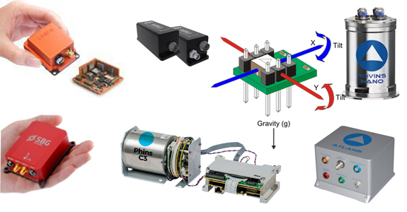
As far as a PPU technology is concerned, the roll and pitch of a vessel can easily be determined with gyroscopes. On the other hand, speed and position, as well as accurate heading, are largely measured with a GNSS system. As already discussed in the article about orientation, sophisticated inertial sensors, at least within the context of piloting inside harbours, provide the added value to measure the vertical heave of a vessel, only if they are equipped of accelerometers, in which case, they are generally referred as: Inertial Motion Unit (IMU). Some MEMS-based IMU are a good option only when a vessel is moving quickly through shallow water.

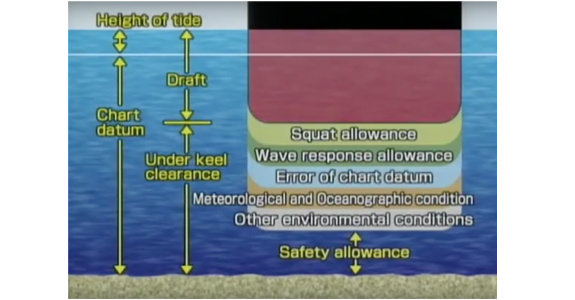
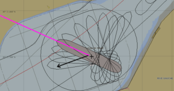
An IMU can flag the imminent SQUAT effect created by an area of lowered pressure that causes the ship to be closer to the seabed than would otherwise be expected. Of course, this is only possible if inertial data is aided by a high-precision GNSS system and if a SQUAT software algorithm is smart enough to give suitable alert. The amount of squat will depend upon several factors but in certain conditions it may be as much as two meters and a good inertial navigation system can feel a heave change of a few centimeters even if it occurs slowly. The asymmetric flow of water around the stern frame reduces the power of the rudder, making steering more difficult and losing stability. The vessel might experience yaw and roll. This is how pilots are alerted of SQUAT already happening. So, a sophisticated PPU as such, can be of good aid to give pilots an early warning. A minor heave change is otherwise impossible to feel without auxiliary sensors, unless the SQUAT is already occurring, and that can be dangerous.

Hyper connectivity

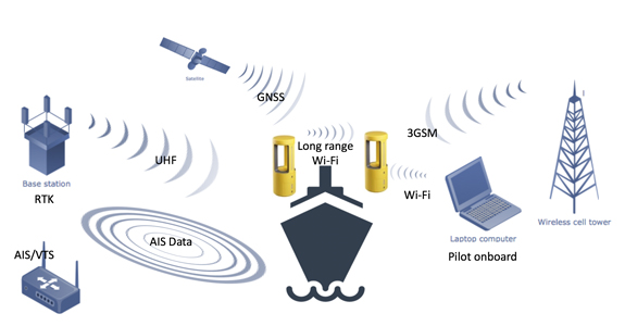
As technology innovation evolves, solutions around VTS become sophisticated. Reliable monitoring of all maritime traffic brings enhanced situational awareness. The picture provided is getting increasingly accurate. Modernization, is giving the ability to integrate data from multiple sensors such as AIS, Radar, CCTV, live weather streaming, real-time feeds from hydrological monitoring systems, drones and much more. Integration is taking place, so is real-time digital display technology in 2D and 3D, which gives an amazing picture of ports and waterways. Nobody knows what the future holds but the idea is becoming quite clear. As far as modern PPU technology is concerned, more situational awareness can be given if a PPU is communicating with the VTS.


If a PPU is equipped with sufficient telemetry equipment such as modems and antennas to work on 3G/4G cellular and UHF/VHF radio and AIS transceivers. Suddenly the PPU becomes another integrated sensor. Some PPUs have a slot where to insert a SIM card, others can even handle two SIM cards and concurrent mobile internet connections.

High precision PPU are meant to be in constant radio connection to UHF/3G base stations to acquire RTK differential corrections. Pilots use Wi-Fi or Bluetooth connections to dialogue with the device. Long-range Wi-Fi allows radio communication to a range of a couple of hundred meters. These are all very important features to be considered when investing in a PPU.

Last but not least, the update rate with which the PPU sensor sends data to the navigation software, is a key factor which falls within the category of hyper connectivity. Generally, the software used by pilots reads data which comes in a format so called NMEA. The string contains navigation data and ought to be sent quite often as input to the pilot software so that it can make the necessary computations to show position, orientation, predicted position and so on. The throughput of a radio link can be strongly affected depending on the amount of information sent and depending on the frequency of these updates. A PPU should send data anywhere between 2 and 5 times per second. Anything above is unnecessary but anything below 2Hz is really not recommended.

Hot-swappable safe battery

Battery autonomy is always a worry for pilots, especially in operations lasting several hours. From the PPU manufacturers´ standpoint, it is more an affliction because the way to provide very long autonomy is by placing very large Lithium-Ion rechargeable battery which poses two big problems.

  1. Extra weight, limiting the ergonomics of a portable system.
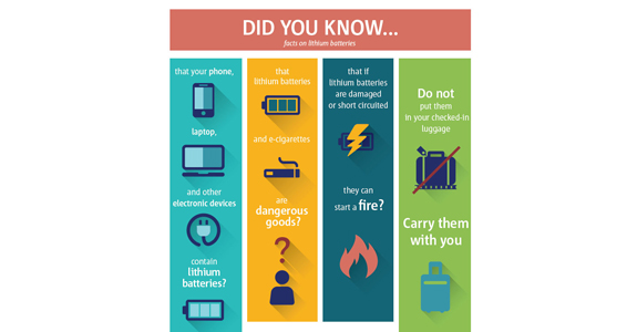
  2. If overheated or overcharged, Li-ion batteries may suffer thermal runaway and cell rupture. This can lead to leakage or explosion. A faulty battery can cause a serious fire. Faulty chargers can affect the safety of the battery because they can destroy the battery’s protection circuit. Often a device which contains this type of batteries is not allowed on board of vessels carrying explosive goods and they are not allowed on planes and helicopters.

The only solution to these issues is to provide smaller batteries which are safe.

nickel–metal hydride battery, abbreviated NiMH is the safest approach, they cost more but that is nothing compared to the threat they represent. Size reduction to assure a lighter PPU with NiMH batteries is tricky, that is, without ultimately affecting the autonomy of the device.  Fortunately, the technology exists today to provide hot-swappable NiMH batteries. A safe battery of average small size and low weight can last 6 to 10 hours, it can be recharged in 3 hours and, if necessary, it can be replaced without causing power loss during operations. This means, endless autonomy and good equipment safety.


How Portable Pilot Units (PPU) determine vessel ROT and accurate heading

HDG & ROT

Accurate heading information can be determined in several ways. The AIS plug does not provide heading information with an update rate which is frequent enough to allow any navigation software to resolve the ROT in real time, while a PPU like BANANAS can measure a ROT < 0.1°/min. To understand why this is so, we need to understand the following 3 main viable solutions:

GNSS Sensors – GPS compass

On water, a single GNSS antenna computing a course from point to point will always provide inaccurate results, unlike terrestrial applications, when it comes to marine navigation, to figure the direction of a vessel, one needs to have two precise GNSS antennas placed as far apart as possible. This is commonly referred with the term: GNSS compass (or GPS compass) and it works according to a very simple concept: by pinpointing the exact positions of both antennas, it is possible to work out the orientation of the imaginary straight line across the two.

(The topic of GNSS precision of position was discussed in another article on PPU technology, if you are not familiar with the terminology contained in the next paragraph, we strongly suggest that you read it. the link is here.)

In RTK Terminology, this  is a Moving Baseline RTK, useful for GPS applications that require vessel orientation. It is a positioning technique in which both reference and rover receivers can move about.  With Moving Baseline RTK, the reference receiver broadcasts data, while the rover receiver performs a synchronized baseline solution. The resultant baseline solution has centimeter-level accuracy. To increase the accuracy of the absolute location of the two antennas, the Moving Reference receiver can use differential corrections from a static source, such as a shore-based reference station.

The formula is: 0.2 degree of accuracy for every meter apart, to have a heading accuracy of 0.01 degree the antennas should be placed 20m apart. The limitations come from the fact that traditional (and old fashioned) PPU have cables between the 2 beacons, so one can gain in accuracy at the price of ergonomics. More recent versions of high precision dual antenna PPU, i.e. made of two wireless beacons, have come to the market to provide the best navigation aid. To understand the technology behind PPU one must also consider that the best systems are a mix of GNSS and Inertial sensors, let´s take a quick look at why this is so.

Inertial sensors

A 3-axis gyroscope is a very good way to determine heading information, some very accurate gyroscopes are made of bulky mechanical parts and cannot be brought onboard. By default, each vessel is equipped with a very good gyroscope, but as already discussed, data from the AIS is far from being in real-time. Some cheaper and lighter electronic equipment, disconnected from the GNSS positioning system, can be brought on board, this does not represent a real PPU, but it is a step forward to help pilots. Some PPU manufacturers have developed some small devices to address the problem of determining an accurate ROT. Manufacturers have tried some techniques to improve its performance, unfortunately, despite attempts, aiding inertial navigation data with magnetometers it is of little help; when it comes to high precision sensors made of compact electronics, a magnetometer is affected by electromagnetic interference and, last but not least, a magnetometer delivers magnetic heading not the true headingmaking magnetometers obsolete. To achieve better performance is to primarily rely on fusing inertial navigation data with the position and heading given by the satellites.

A IMU (Inertial Motion Unit) made of 3-axis accelerometer/gyroscope provides better performance. Some of these sensors are very sophisticated. The most advanced kind works on fiber-optic technology, providing very accurate heading, roll, pitch, speed, heave and position. They can be considered as reliable navigation devices even without aiding from a GNSS positioning system and are often used to navigate submarines or objects into space. Unfortunately, they cost a fortune, they are very large and extremely heavy to carry. Some lighter and smaller versions are quite precise and could work very well as a tool for maritime pilots, but they are still expensive, not so small (probably the size of a bottle) and are accurately reliable without GNSS position aiding for a limited time (a matter of seconds). These types of IMU are commonly used in survey applications which primarily rely on satellite navigation. These devices come in hand in case of absence of satellite reception (dead reckoning) which generally occurs inside tunnels, under bridges and in urban areas. Clearly, not an issue when navigating a 300m cargo vessel.

Therefore, the optimal solution comes from another type of inertial navigation sensors. Since the introduction of Micro-Electro-Mechanical Systems (MEMS), the size of a decent IMU has been enormously reduced a matter of centimeters, their weight to a few hundred grams and their price to around 2,000 dollars. They are less precise but still excellent since they are constantly aided by satellite navigation.

A combination of both GNSS & Inertial sensors (Kalman filter)

A good dual-antenna system (i.e. a GNSS compass) can work without a IMU, the concept of using accelerometers and RTK positioning is rigorously necessary to measure the heave a vessel, which is primarily useful to gage the SQUAT effect. When using a IMU in combination with GNSS sensors, we say that we fuse the GNSS navigation data with inertial navigation data. If accelerometers are not used, the sole use of gyroscopes (even not the most accurate ones) is still sufficient to determine accurate heading, roll, pitch, speed and position. In this case, we do not say that we fuse the data. However, a good PPU still needs to elaborate accurate navigation data from a series of measurements observed over time, containing internal state estimates of a linear dynamic system from a series of noisy measurements and other inaccuracies. For overcoming this difficulty, a good PPU must have an algorithm also known as Kalman filter, which produces estimates of unknown variables that tend to be more accurate than those based on a single measurement alone, by estimating a joint probability distribution over the variables for each timeframe. It sounds complicated, and in fact it is indeed. A good IMU will even have an advanced Kalman filter.

Bottom line: to determine accurate heading and a precise ROT, a pilot ought to have two wireless high-precision GNSS antennas/receivers arranged to implement a GNSS compass with Moving Baseline RTK technique, a good PPU must implements at least a Kalman Filter. If a good MEMS based IMU is embedded inside the PPU, better performance is guaranteed.

How a PPU determines accurate position and speed

Position & SOG

Pilots are in demand of berthing aid tools that provide accurate vessel location in real-time. There are several ways of providing the necessary positioning/speed accuracy.

A PPU will facilitate efficient and safe manoeuvring within the entire navigation harbour zone enhancing vessel trajectory. To better understand what technological solutions are available to assure accurately positioning of a vessel, the following alternatives must be considered

AIS

The Automatic Identification System (AIS) is a shipboard broadcast system that acts like a transponder, operating in the VHF maritime band and transmitting real time information of the vessel. It relies on GNSS as primary positioning source. The onboard system uses a transponder system that operates in the VHF maritime band and continuously transmits vessels identity, geographic position, speed, course, vessel type, and cargo information along with other relevant information to all other AIS equipped vessels within range, in a real-time automated manner. The AIS uses Self-Organizing Time Division Multiple Access (SOTDMA) technology to meet a high broadcast rate and ensure reliable ship-to-ship operation. The AIS transponders send data every 2 to 10 seconds depending on a vessel’s speed while underway.

Often, pilots use a very light electronic equipment called AIS plug, or Pilot Plug, or AIS Pilot Plug. This genius tool, which can be considered as the precursor of a PPU, is literally plugged into the AIS plug on board and, acting as a sensor, it sends AIS data to the pilot either via Bluetooth or Wi-Fi.  Besides the fact that a pilot plug costs only a few hundred dollars, it can be put inside the pilot´s pocket and it has a very long battery autonomy. As of today, it is the most widely used navigation aid tool by maritime pilots.

The problem is that the GNSS position Accuracy from AIS is generally 2.5m-4.0m CEP-Horizontal so a pilot lacks control of precision, he cannot always trust to receive the necessary berthing aid in terms of precision of position, so a pilot gets what he gets…. Data accuracy is limited to a degree of precision which might not be sufficiently high, causing a poor evaluation of speed.  Besides, if one considers that data is provided with a very low update rate, the SOG is not calculated with the accuracy required in difficult situations, furthermore, a low update rate, makes any sophisticated feature of the pilot software giving a predicted position of the vessel, obsolete.

SBAS

When it comes to improving position, a Satellite-based Augmentation System (SBAS) is a good alternative. Using geostationary satellites which broadcast the augmentation information, it is possible to greatly improve the position accuracy to 0.5m-1m CEP-Horizontal.

A relatively important limitation is that the its network coverage is not global, WAAS operates in North America, EGNOS in Europe, SDCM in Russia, GAGAN in India, MSAS in Japan, BDSBAS in China, so it is mainly in the northern hemisphere.

Finally, although SBAS is indeed widely used and rather precise in most applications, it does not deliver the highest precision needed in extreme cases where SOG must be precise. The precision or position on the vertical axis is circa double the horizontal accuracy, limiting in some case to navigate in shallow water, where UKC must be strictly calculated.

Altogether, when it comes to speed accuracy, it is a good GNSS technology, although in some cases it is necessary to bring their own receiver on board, hence you need a PPU. In fact, the most sophisticated receivers are generally not available on board.  SBAS receivers operate mainly in single point position (SPP) mode and estimate velocity either by differencing two consecutive positions (i.e., approximating the derivative of user position) or by using Doppler measurements related to user-satellite motion.

The former approach is the simplest to implement, but it has a meter per second–level of accuracy due to the dependence on pseudorange-based position accuracy. In contrast, Doppler frequency shifts of the received signal produced by user-satellite relative motion enables velocity accuracy of a few centimeters per second.

L-BAND

Another viable alternative is to have a receiver so called L-Band (RTX) which provides an accuracy of position in the range of 1 decimeter: 4cm -10 cm CEP-Horizontal.

Besides the fact that its initiation time can take several minutes, a PPU based on this technology is great. Likewise SBAS, it is a correction service which can be delivered via satellites, i.e no need of a land base station, receiver modem, antenna, clear line of sight etc…. Its coverage is global and it is a paid service (a couple of thousand dollars per year). This is a new technology delivered by Trimble (see Trimble Centre Point RTX) and not all GNSS receivers are equipped with this sort of advanced algorithm. Pilot must have a dedicated antenna/receiver, i.e. a PPU

RTK

When it comes to high precision navigation, the best approach is Real-Time Kinematics (RTK) which provides an accuracy of position or 1cm-2cm CEP-Horizontal. RTK delivers outstanding performances in terms of precision and velocity can be calculated with an accuracy of 1cm/sec. Furthermore, the technology can be used as relative positioning system (a.k.a. relative RTK), meaning that it is possible to evaluate with extreme accuracy the distance between a RTK base and RTK rover, this has enormous applications in off-shore operations and for a implementing the so called Moving Baseline RTK, that is, a technique useful for GPS applications that require vessel orientation.

When used as an RTK rover, i.e. inside a harbor, it requires a base station on land to deliver the corrections: a receiver requires integrating a radio modem, receivers and having either a good line of sight or mobile data coverage (when over IP). It must be pointed out that these are not real issues. Differential correction services nowadays is a challenge of the past, several operators worldwide have equipped harbours with networks of base stations,  mobile network technology works. The issue comes for the need of having such smart electronics available on board. In most cases, this type of precision equipment must be brought on board by pilots. Such tools are typically used by land surveyors and they generally are, heavy, bulky and full of cables. Not so ergonomic for a pilot to bring on board. That is why PPUs are adapted around the needs of pilots who must bring onboard light and easy to carry equipment with little amount of cables (or none at all, if possible).

Precision and sophistication has a price tag. A good RTK receiver which works on all GNSS constellations (GPS, Glonass, Beidou, Galileo), with UHF/GSM modem, and an output at 20Khz + RTK correction service can costs USD 15,000. Most PPU consist of a dual-antenna system, so the price range is far from a pilot plug, but so is its performance.